Bentley Systems Announces Availability of OpenGround Cloud
Technology

Bentley Systems Announces Availability of OpenGround Cloud

Bentley Systems, Inc, a leading global provider of comprehensive software and digital twins services for advancing the design, construction, and operations of infrastructure, on Monday, announced the availability of OpenGround Cloud, a new cloud service that enables geotechnical professionals to access reliable geotechnical data for better engineering decision support and to improve collaboration across the entire supply chain.

OpenGround Cloud offers a complete solution for planning, data entry, borehole log production, lab data management, reporting, visualisation, and more. The cloud service improves collaboration across multi-disciplinary project teams and significantly increases the value of geotechnical data by making it easily accessible to key project stakeholders.

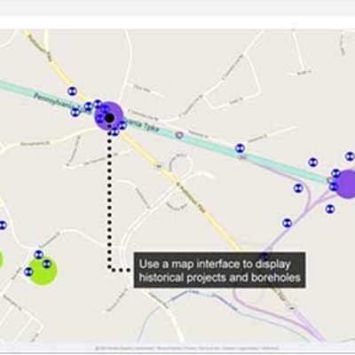
Geotechnical project team dynamics and the applications and services they require to manage natural resources are changing rapidly. Relevant geotechnical data is typically dispersed across various applications and devices and can be cumbersome to gather and consolidate, complicating the effective and timely use of this data. Now, with OpenGround Cloud, geotechnical engineers can readily access reliable, high-quality current and historical geotechnical data for the modelling, stimulation and analysis of infrastructure projects’ ground conditions.

Scott Devoe, Senior Director, Geotechnical Information Management, Bentley Systems, said, “OpenGround Cloud provides a single enterprise repository of multiple data sources for all ground investigation projects – a long-sought improvement for geotechnical and geological professionals. It eliminates the need to retain copies or to exchange data and ensures that everyone in the supply chain has the correct access rights to the most current version. As a result, OpenGround Cloud helps minimise project delays due to encountering unforeseen ground risks during construction.”

Richard O’Brien, Principal Process Engineer with Atkins, said, “From a risk management perspective, we are now able to more easily identify the gaps in data, to highlight risk items and, if required, assist in the planning of targeted ground investigations. From the tender process, when local site data availability is limited, through to detailed design, we are now able to undertake data-driven assessments to aid in our decision-making.”

O’Brien added, “OpenGround Cloud gives us the ability to determine and cross-reference the organisation’s geotechnical parameters and correlations with those available from literature sources. Tender design is made more efficient and we can consider a wider range of site properties leading to reductions in geotechnical risk. Ground investigations are planned more effectively taking into consideration multidiscipline and multi-project data leading to reduced costs. And, detailed designs are delivered from a more complete perspective, which leads to greater value for the client.”

Cedric Allenou, Ground Engineering Lead, Lower Thames Crossing, said, “OpenGround Cloud improved the workflow for all members of the team. The various add-ins are faster within the cloud version of the database, which is useful when dealing with large datasets such as CPT data.”

Allenou continued, “In addition, maintaining the link with the database when members of other organisations need to access the data has also improved the workflow due to the servers being cloud-based. As a result, external support teams can more easily solve issues that arise. The process allows rapid responses and minimises potential downtime on the project.”

OpenGround Cloud is a secure, cloud-based collaboration platform for geotechnical data management. The multi-project environment allows engineering teams to collaborate while collecting data in the field, reporting, scheduling or integrating data with their design software. The platform has several connected apps that provide team members with the capabilities they need in a modern, intuitive, and easy-to-use environment.

The original story is put up on: https://infrastructuretoday.co.in/web-exclusive/bentley-systems-announces-availability-of-openground-cloud/117819
Bentley Systems, Inc, a leading global provider of comprehensive software and digital twins services for advancing the design, construction, and operations of infrastructure, on Monday, announced the availability of OpenGround Cloud, a new cloud service that enables geotechnical professionals to access reliable geotechnical data for better engineering decision support and to improve collaboration across the entire supply chain. OpenGround Cloud offers a complete solution for planning, data entry, borehole log production, lab data management, reporting, visualisation, and more. The cloud service improves collaboration across multi-disciplinary project teams and significantly increases the value of geotechnical data by making it easily accessible to key project stakeholders. Geotechnical project team dynamics and the applications and services they require to manage natural resources are changing rapidly. Relevant geotechnical data is typically dispersed across various applications and devices and can be cumbersome to gather and consolidate, complicating the effective and timely use of this data. Now, with OpenGround Cloud, geotechnical engineers can readily access reliable, high-quality current and historical geotechnical data for the modelling, stimulation and analysis of infrastructure projects’ ground conditions. Scott Devoe, Senior Director, Geotechnical Information Management, Bentley Systems, said, “OpenGround Cloud provides a single enterprise repository of multiple data sources for all ground investigation projects – a long-sought improvement for geotechnical and geological professionals. It eliminates the need to retain copies or to exchange data and ensures that everyone in the supply chain has the correct access rights to the most current version. As a result, OpenGround Cloud helps minimise project delays due to encountering unforeseen ground risks during construction.” Richard O’Brien, Principal Process Engineer with Atkins, said, “From a risk management perspective, we are now able to more easily identify the gaps in data, to highlight risk items and, if required, assist in the planning of targeted ground investigations. From the tender process, when local site data availability is limited, through to detailed design, we are now able to undertake data-driven assessments to aid in our decision-making.” O’Brien added, “OpenGround Cloud gives us the ability to determine and cross-reference the organisation’s geotechnical parameters and correlations with those available from literature sources. Tender design is made more efficient and we can consider a wider range of site properties leading to reductions in geotechnical risk. Ground investigations are planned more effectively taking into consideration multidiscipline and multi-project data leading to reduced costs. And, detailed designs are delivered from a more complete perspective, which leads to greater value for the client.” Cedric Allenou, Ground Engineering Lead, Lower Thames Crossing, said, “OpenGround Cloud improved the workflow for all members of the team. The various add-ins are faster within the cloud version of the database, which is useful when dealing with large datasets such as CPT data.” Allenou continued, “In addition, maintaining the link with the database when members of other organisations need to access the data has also improved the workflow due to the servers being cloud-based. As a result, external support teams can more easily solve issues that arise. The process allows rapid responses and minimises potential downtime on the project.” OpenGround Cloud is a secure, cloud-based collaboration platform for geotechnical data management. The multi-project environment allows engineering teams to collaborate while collecting data in the field, reporting, scheduling or integrating data with their design software. The platform has several connected apps that provide team members with the capabilities they need in a modern, intuitive, and easy-to-use environment. The original story is put up on: https://infrastructuretoday.co.in/web-exclusive/bentley-systems-announces-availability-of-openground-cloud/117819

Next Story
Technology

Building Faster, Smarter, and Greener!

Backed by ULCCS’s century-old legacy, U-Sphere combines technology, modular design and sustainable practices to deliver faster and more efficient projects. In an interaction with CW, Rohit Prabhakar, Director - Business Development, shares how the company’s integrated model of ‘Speed-Build’, ‘Smart-Build’ and ‘Sustain-Build’ is redefining construction efficiency, quality and environmental responsibility in India.U-Sphere positions itself at the intersection of speed, sustainability and smart design. How does this translate into measurable efficiency on the ground?At U..

Next Story
Infrastructure Transport

Smart Roads, Smarter India

India’s infrastructure boom is not only about laying more kilometres of highways – it’s about building them smarter, safer and more sustainably. From drones mapping fragile Himalayan slopes to 3D machine-controlled graders reducing human error, technology is steadily reshaping the way projects are planned and executed. Yet, the journey towards digitisation remains complex, demanding not just capital but also coordination, training and vision.Until recently, engineers largely depended on Survey of India toposheets and traditional survey methods like total stations or DGPS to prepare detai..

Next Story
Real Estate

What Does DCPR 2034 Mean?

The Maharashtra government has eased approval norms for high-rise buildings under DCPR 2034, enabling the municipal commissioner to sanction projects up to 180 m on large plots. This change is expected to streamline approvals, reduce procedural delays and accelerate redevelopment, drawing reactions from developers, planners and industry experts about its implications for Mumbai’s vertical growth.Under the revised DCPR 2034 rules, buildings on plots of 2,000 sq m or more can now be approved up to 180 m by the municipal commissioner, provided structural and geotechnical reports are certified b..

Advertisement

Subscribe to Our Newsletter

Get daily newsletters around different themes from Construction world.

STAY CONNECTED

Advertisement

Advertisement

Advertisement

Talk to us?