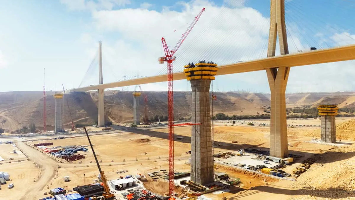
- Vinay Kumar Singh, Managing Director, NCRTCThe National Capital Region Transport Corporation (NCRTC), a JV of the Government of India and the states of Haryana, Rajasthan, Uttar Pradesh and Delhi, is mandated to implement the Regional Rapid Transit System (RRTS) project across the National Capital Region (NCR), ensuring balanced and sustainable urban development through better connectivity and access. Vinay Kumar Singh, Managing Director, NCRTC, tells us more about RRTS and the innovative technologies employed for the project, especially the Continuous Operating Reference Station (CORS) network.Please provide us a short brief about RRTS.RRTS is a first-of-its-kind, rail-based, high-speed, high-frequency regional transit system with design speed of 180 kmph and an average speed of 100 kmph. India’s first RRTS corridor will connect the National Capital Territory (NCT) of Delhi with Meerut passing through towns such as Sahibabad, Ghaziabad, Muradnagar and Modinagar in Uttar Pradesh. The rail-based corridor will have a total length of 82.15 km, 25 stations and two maintenance depots. The system will include state-of-the-art civil structures, ballast-less rail tracks, overhead electrification, signalling, train control, telecommunication systems and rolling stock. About 21 km of the RRTS line from Meerut South to Modipuram Depot will also be used to operate local transit services (metro services) within Meerut city.The project is expected to serve about 0.8 million commuters daily by FY2025, increasing to 1.14 million by FY2041. RRTS will connect metropolitan and big cities, towns and other suburban and urban centres in NCR, and will run right across city centres, thus providing a seamless multimodal transit network to the entire region. A fast and safe mobility system like RRTS will not only improve regional connectivity but also help promote polycentric, balanced and sustainable urban development of the entire NCR. The project will also address issues of hazardous air pollution, severe vehicular congestion and unmanageable urban sprawl.What are the new construction technologies NCRTC is using in construction of the RRTS corridor?Making RRTS a technologically advanced system has been one of the core strategies since the beginning. I have always encouraged my team to adopt best-in-class technological solutions not only for enhancing passenger experience but also in the implementation of the project. We are using innovative IT-based tools and modules for various aspects of project implementation. ‘SPEED’, the tool for project monitoring and management developed by our own IT team, has been refined iteratively with our own implementation experience and has become so effective that NCRTC is even supporting other public transit organisations to implement it for their project management. In addition to SPEED, we are using multiple IT-enabled modules/platforms that are helping us make implementation more effective and efficient. These include common data environment (CDE), which helps teams collaborate and exchange documents on one platform, and building information modelling (BIM), a virtual reality-based technology that provides a digital representation of the physical and functional characteristics of the RRTS project. BIM uses CDE to share intelligent 3D models and enables document management, coordination and simulation on a real-time basis, forming a reliable foundation for decisions during the project lifecycle. Another innovative technology we implemented successfully is the Continuous Operating Reference Station (CORS) network with multiple global navigation satellite system (GNSS) base stations.Please tell us more about the innovative CORS technology.Linear infrastructure projects demand high accuracy level of surveys to achieve the planned alignment. Given the design speed of 180 kmph and alignment either on viaducts or in tunnels, there is hardly any margin of tolerance in case of RRTS civil structures. The requirement of meeting scheduled timelines necessitates simultaneous working on multiple sites. Also, ballast-less tracks for RRTS are required to be laid at an accuracy level of as low as less than 5 mm.Considering the criticality of accuracy of surveys required, NCRTC went beyond the technologies being used in the country like DGPS and Total Station (TS) and took up the challenge of the innovative application of the CORS network, which provides real-time accurate coordinates of any point within the geographical limits of the network. NCRTC is using the CORS network for the first time in India to construct a mega infrastructure project. Our engineering partners working on the Delhi-Ghaziabad-Meerut RRTS project are using this technology and have lauded this pathbreaking initiative.How is this technology different from conventional methods?In conventional methods of survey, a combination of TS and DGPS is generally used. Permanent benchmarks/control points are set up with the help of DGPS. Once the absolute location of the control point is established, a subsequent survey to determine the coordinates of any point is carried out using TS. To determine the coordinates of any point, TS is set up over a known point or with line of sight to two or more points with known location. CORS is a GNSS-based technology that ensures complete accuracy in the construction of a predetermined corridor to achieve the planned alignment. For a linear project, a network of reference stations is established at about every 10-15 km along the corridor. These reference stations are connected to the control centre, which provides real-time kinematics (RTK) corrections to the rovers on the basis of inputs provided from multiple satellites. Rovers use inputs from the satellites and RTK correction broadcasted by the control centre to provide the position of any point precisely, eliminating human error or accumulation of error.What are the areas of applications of CORS?CORS can be used in surveying and mapping, territorial planning, cadastral management, engineering construction, traffic monitoring, and public security. In India, this system can be used by different local authorities to mark routes and identify utility services with accurate position, which can save time and manpower during laying of new utilities, construction of projects and maintenanceWhat are the advantages of using this technology in infrastructure projects?As elaborated above, CORS uses a network of reference stations and multiple satellites, which eliminates the risk of cumulative errors, minimises human interface and helps the surveyor in checking the quality level before taking readings. Moreover, a survey with CORS can be done by one person as against a team of persons required in a conventional survey, resulting in significant savings in time and cost. In this system, no post processing of data is required, as all values are provided on a real-time basis. As it is a network-based system, no physical maintenance is required. In a conventional survey, control points are to be protected throughout the project time and the instrument (TS) needs to be frequently calibrated.Also, how is this technique eco-friendly?RRTS is being implemented as a sustainable rapid transit project to promote the use of public transport to reduce traffic congestion and pollution in NCR. According to estimates, once fully implemented, RRTS will reduce ~2,50,000 CO2e per year. We are adopting best-in-class technologies available to achieve our goal. CORS is preferred over other alignment technologies as, apart from its technological advancements. it does not require activities like digging the ground and cutting of trees for position benchmarking. As there is no need to set up base reference frames, there is lesser crew movement, resulting in saving fuel and time and making operations more eco-friendly.