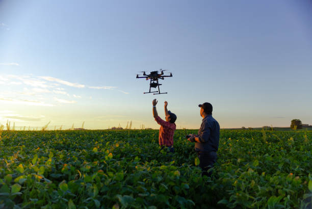
Nashik uses drones for land assessment for over two years
Real Estate

Nashik uses drones for land assessment for over two years

Nashik was one of the first districts in the state to begin using drones for land assessment and digitisation of properties in gaothan villages (old villages) in rural areas in 2020, while a section of farmers in Pune and Kolhapur have been spraying insecticides with them.

Mahesh Shindhe, the Nashik superintendent of land records, said on Tuesday that drones have been used to assess 622 gaothan villages so far. This comes after finance minister Nirmala Sitharaman announced the promotion of Kisan Drones for crop assessment, digitisation of land records, and insecticide spraying from the next fiscal year in her Union Budget speech.

The British regime did not survey the gaothan areas of villages where people lived before independence. Houses were built without the use of a property card or dimensions. Because there is no reliable information about the property owner, banks refuse to fund the development of such properties.

Shinde said that this is why the city survey is conducted in such remote locations. The property is indexed, and the property owner is determined based on gram panchayat authentication. The property holder receives the property card that has been prepared.

In Nashik, there are approximately 1,300 gaothan villages. With the help of the Survey of India, land assessment using drones is carried out.

After the owner's property has been delineated and captured by drones, the Survey of India reviews it for final approval. Landowners are then given property cards by the administration.

Cut to the farming sector. Farmers in rural Pune, Kolhapur, Sangli, and Satara have been spraying insecticides and nutrients absorbed through leaves with drones. Arun Swant, a sugarcane farmer from Sangli's Palus town, said he rented a drone to spray insecticides because it made the job easier.

On a trial basis, some sugar mills have begun spraying pesticides in sugar cane farms using drones.The millers claimed that subsidising drones through the Kisan Drone programme would help modernise agriculture and boost yields.

Jitendra Bidwai, the president of the Junnar tehsil grape growers' association in the Pune district, has been spraying insecticides with drones.

Image Source

Also read: Assam govt to map 700 villages via drone technology

Nashik was one of the first districts in the state to begin using drones for land assessment and digitisation of properties in gaothan villages (old villages) in rural areas in 2020, while a section of farmers in Pune and Kolhapur have been spraying insecticides with them. Mahesh Shindhe, the Nashik superintendent of land records, said on Tuesday that drones have been used to assess 622 gaothan villages so far. This comes after finance minister Nirmala Sitharaman announced the promotion of Kisan Drones for crop assessment, digitisation of land records, and insecticide spraying from the next fiscal year in her Union Budget speech. The British regime did not survey the gaothan areas of villages where people lived before independence. Houses were built without the use of a property card or dimensions. Because there is no reliable information about the property owner, banks refuse to fund the development of such properties. Shinde said that this is why the city survey is conducted in such remote locations. The property is indexed, and the property owner is determined based on gram panchayat authentication. The property holder receives the property card that has been prepared. In Nashik, there are approximately 1,300 gaothan villages. With the help of the Survey of India, land assessment using drones is carried out. After the owner's property has been delineated and captured by drones, the Survey of India reviews it for final approval. Landowners are then given property cards by the administration. Cut to the farming sector. Farmers in rural Pune, Kolhapur, Sangli, and Satara have been spraying insecticides and nutrients absorbed through leaves with drones. Arun Swant, a sugarcane farmer from Sangli's Palus town, said he rented a drone to spray insecticides because it made the job easier. On a trial basis, some sugar mills have begun spraying pesticides in sugar cane farms using drones.The millers claimed that subsidising drones through the Kisan Drone programme would help modernise agriculture and boost yields. Jitendra Bidwai, the president of the Junnar tehsil grape growers' association in the Pune district, has been spraying insecticides with drones. Image Source Also read: Assam govt to map 700 villages via drone technology

Next Story
Technology

Building Faster, Smarter, and Greener!

Backed by ULCCS’s century-old legacy, U-Sphere combines technology, modular design and sustainable practices to deliver faster and more efficient projects. In an interaction with CW, Rohit Prabhakar, Director - Business Development, shares how the company’s integrated model of ‘Speed-Build’, ‘Smart-Build’ and ‘Sustain-Build’ is redefining construction efficiency, quality and environmental responsibility in India.U-Sphere positions itself at the intersection of speed, sustainability and smart design. How does this translate into measurable efficiency on the ground?At U..

Next Story
Infrastructure Transport

Smart Roads, Smarter India

India’s infrastructure boom is not only about laying more kilometres of highways – it’s about building them smarter, safer and more sustainably. From drones mapping fragile Himalayan slopes to 3D machine-controlled graders reducing human error, technology is steadily reshaping the way projects are planned and executed. Yet, the journey towards digitisation remains complex, demanding not just capital but also coordination, training and vision.Until recently, engineers largely depended on Survey of India toposheets and traditional survey methods like total stations or DGPS to prepare detai..

Next Story
Real Estate

What Does DCPR 2034 Mean?

The Maharashtra government has eased approval norms for high-rise buildings under DCPR 2034, enabling the municipal commissioner to sanction projects up to 180 m on large plots. This change is expected to streamline approvals, reduce procedural delays and accelerate redevelopment, drawing reactions from developers, planners and industry experts about its implications for Mumbai’s vertical growth.Under the revised DCPR 2034 rules, buildings on plots of 2,000 sq m or more can now be approved up to 180 m by the municipal commissioner, provided structural and geotechnical reports are certified b..

Advertisement

Subscribe to Our Newsletter

Get daily newsletters around different themes from Construction world.

STAY CONNECTED

Advertisement

Advertisement

Advertisement

Talk to us?