Man is prone to exploiting the vulnerabilities of nature. And when the vagaries of nature hit back, it leads to a ‘natural disaster’. It is not until such catastrophes impact the basic nature of human existence is there any attempt to solve them. Joshimath, a town and municipal board in Chamoli district in Uttarakhand serves as a perfect example. The Uttarakhand flood of 2021 and its aftermath severely affected the region beginning in February 2021. Fast forward to 2023, the town is now sinking.
Joshimath is situated at an altitude of 6,200 ft above sea level, in the lower Himalayas. The town is situated in the middle of a hill bounded by Dhauliganga and Alaknanda on one side and Karmanasa and Dhaknala on the other. In addition to Joshimath, several settlements can be found on the lower and middle slopes. These include Chami, Shelong, Khanoti Chatti, Animath, Vishnuprayag, Khan, Parsari, Ganeshpur, Sunil, Gaukah, Dadon, Regaon, Oucha, Auli, Kharori, Kuni, Paiyan, Khancha, Barhgaon, Paini and Vishnupuram.
The recent crisis in Joshimath began with cracks on walls at an accelerated pace. Reports cited that owing to land subsidence, 863 buildings in Joshimath were found to have cracks and numerous structures had moderate or major damages.
The cracks caused by land subsidence in Joshimath is not an overnight phenomenon. This has been an ongoing issue since the 1970s. In 1978, a panel headed by Garhwal commissioner Mahesh Chandra Mishra submitted a report stating that major construction should not be done in the city and the Niti and Mana valleys because they are on moraines, which are masses of rocks, sediment and soil deposited by glaciers.
Why did it happen?
Joshimath has grown in size resulting in haphazard development, as is the problem with other towns located 5,000 ft above sea level with all development happening on loose soil. Unplanned expansion has also amended the natural flow of water; in the absence of systematic drainage, water has been forced to chart alternative routes. This water has been seeping down into the crystalline porous rocks, causing them to become even more brittle. Further, this town is located in Zone V of India’s seismic zonation scheme and earthquake motion is well known to turn loosely packed, water-saturated soil to liquid.
Dikshu C. Kukreja, Managing Principal, CP Kukreja Architects says “Many mountain towns in our country, like Joshimath, don't fall within the official urban limit. Some of these come under small nagar palikas(city councils) and panchayats(village councils)that don’t follow any masterplan. As a result, development in such areas is sporadic and happens in a piece-meal fashion. Further, a lack of systematic guidelines for development in such eco-sensitive zones may have led to unregulated urban planning in the town.”
Infrastructural compulsions
Ever since the tragedy struck, one of India’s largest energy conglomerates has become a centre of attraction with accusations being levelled against it for being a contributor. Much of this concerns an event that unfolded on December 24, 2009. A report authored by MPS Bisht Piyoosh Rautela states, “Despite being fully aware of the geological/environmental vulnerability of the area, a number of hydroelectric schemes have been sanctioned around Joshimath and Tapovan. The Vishnugad HE Project is one such scheme. The head race tunnel of the project traverses through the geologically fragile area below Joshimath. It is interesting to note that a private company was preferred by the National Thermal Power Corporation (NTPC) over the Geological Survey of India for undertaking geological investigations related to the project. These investigations failed to take cognisance of the earlier geological investigations carried out in the area and did nothing to establish the depth of overburden all through the tunnel alignment. A tunnel-boring machine (TBM) was employed for excavating the head race tunnel. On December 24,2009, it punctured a water-bearing strata some 3 km inward the left bank of Alaknanda near Shelong village. The site was more than a kilometre below the surface, somewhere below Auli, according to the project authorities. The water discharge was reportedly between 700 and 800 litre per second. The aquifer discharge was about 60-70 million litre daily, enough to sustain 2-3 million people. Even after a month, the aquifer had not dried out.”
After the current disaster, locals have attributed the problems to the 12-km-long Tapovan Vishnugad hydroelectric project. Veteran environmentalist Ravi Chopra has been reportedly quoted saying there is adequate reason to believe that what is being witnessed in Joshimath is a result of the tunnelling exercise. The National Institute of Hydrology (NIH) has reportedly cited that the water gushing out of cracks in the Joshimath land subsidence appears to be distinct from the water in the tunnel in Tapovan, according to a preliminary test report.
In the present day
Owing to an ongoing investigation of the phenomenon, experts have refused to comment on the issue. CW has made an attempt to reach out to experts, including a senior representative from Wadia Institute of Himalayan Geology, who has asserted that the appropriate findings have been submitted to National Disaster Management Authority.
After the land subsidence, large-scale construction has been temporarily suspended in the region. The Joshimath subsidence is being investigated by the Uttarakhand government, led by Chief Minister Pushkar Singh Dhami. Scientists from eight institutes have submitted their reports to NDMA. Cracks have been found in 863 buildings, 505 of which have experienced serious cracks. Aside from this, 188 lpm of water were still leaking from the JP Colony of Joshimath; 957 members of 286 families have been forced to relocate, and 360 families have received Rs 37 million in relief.
Possible solutions
Kukreja says “Unchecked development that defies nature is the first and foremost cause of natural disasters. When we plan a development, it is really important to understand town planning principles. And one of the fundamental principles of town planning is to design and plan according to the context, which means considering the natural conditions of the land, particularly in a mountainous, eco-sensitive town like Joshimath. First and foremost, a thorough study of the built environment in such sensitive zones should be carried out on a regular basis. The survey can also include areas outside Garhwal and Uttrakhand region, and go on to cover sensitive areas in Himachal Pradesh, Jammu and Kashmir, and the hilly regions of Northeast India. The states can then be directed to conduct rapid research and investigation on the condition of the existing buildings in these regions. This will help in identifying the degree of damage or the degree of threat posed to the local buildings, based on which mitigation efforts can be determined”
The geography of Joshimath is prone to a crisis, which has been catalysed by present-day developments. There are many such areas across India that can be at similar risk. Solutions deemed fit by experts include:
Vegetation cultivation: On slopes, planting vegetation can assist in anchoring the soil and preventing erosion. Trees and other plants with deep roots are especially good at stabilising slopes.
Control of drainage: In hilly areas, drainage systems must be properly managed and maintained because poor drainage can cause land sinking. Installing culverts or other drainage structures to divert water away from slopes and stop erosion may be necessary.
Establishing solid foundations: In hilly communities, strengthening the foundations of buildings to prevent them from sliding or collapsing may be necessary in some instances. This could involve strengthening the foundations or underpinning them.
Zoning and planning: Buildings can be avoided in areas that are prone to erosion or landslides with careful planning and zoning. This may necessitate requiring the use of specialised construction methods in high-risk areas or designating specific areas as no-build zones.
Keeping slopes stable: Stabilising slopes with methods like terracing or retaining walls is an effective way to stop erosion and landslides.
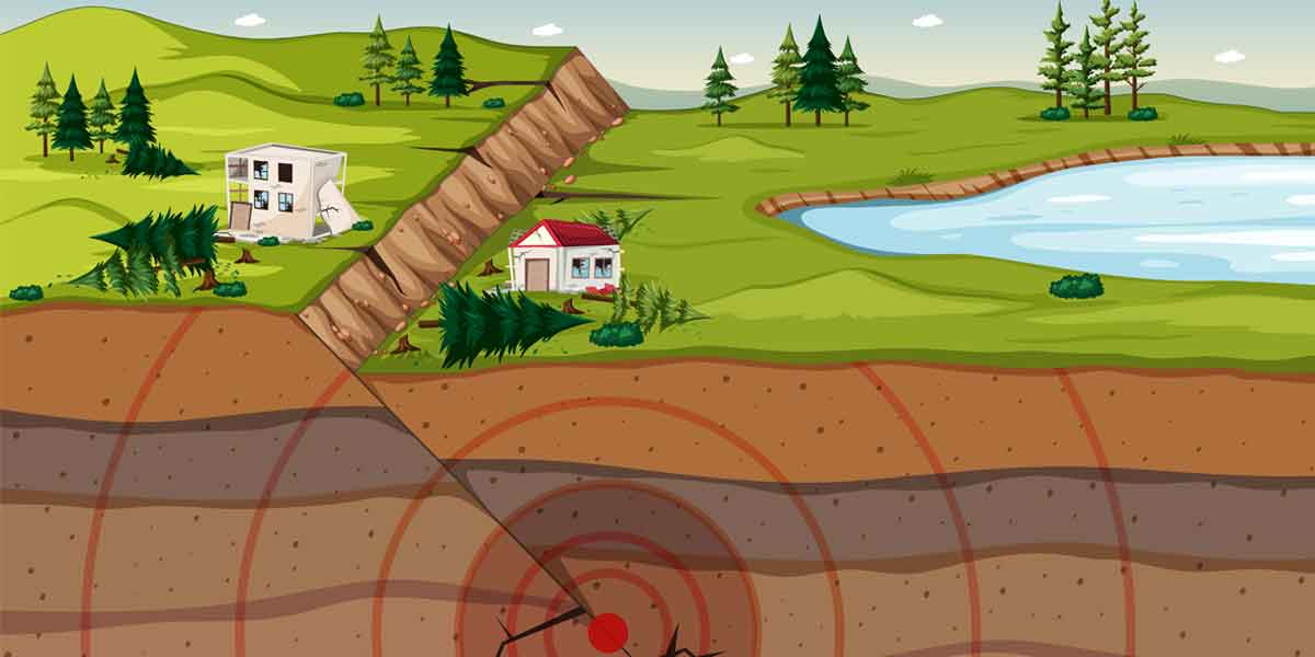
What exactly is sinking or subsidence?
The surface of the ground sinking or settling is known as land subsidence. When the ground beneath the surface collapses or compacts, the surface can sink. A number of things can lead to land subsidence, including:
Underground resource extraction: The removal of oil, natural gas or other underground resources can lead to the ground sinking and the collapse of the empty space that is left behind.
Soil consolidation: When subjected to heavy loads or saturated with water, soil can harden or compress over time. The surface of the ground may sink as a result.
Erosion: The ground may become weaker and more prone to subsidence as a result of erosion.
Depletion of aquifers: The ground above an underground aquifer may sink as the water level drops if water is pumped out of it faster than it can be replenished.
Landslides and faults: Land subsidence can also be caused by landslides and faulting because geological forces can cause the ground to shift or collapse.
Subsidence of land can cause many problems, such as flooding and harm to infrastructure and buildings. In areas where subsidence is a possibility, careful monitoring and management of land use is essential.