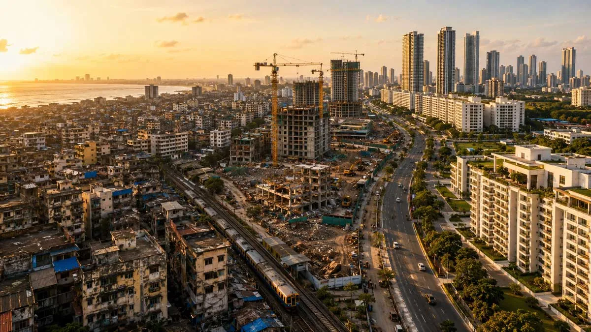
+
KDA to use DGNSS to demarcate its properties
Real Estate

KDA to use DGNSS to demarcate its properties

Kanpur Development Authority (KDA) will demarcate its properties using the Differential Global Navigation Satellite System. Following a presentation by its developer, KDA vice-chairman Arvind Singh directed that this digital technology be used first in the New Kanpur City being developed by the Authority between Mainavati Road and Kalyanpur-Bithoor Road.

He claims that this technique can be used to demarcate properties in remote areas. This allows for the simple geotagging of any land parcel. We can also create a digital map of the authority's properties using this technique, he added. According to SBA Rai, public relations officer, measuring properties in the past required a lot of manpower and time, and there was also the possibility of ankle error (angular error) or human error. However, using DGNSS technology, lands could be measured by a single person with minimal error, according to Rai.

Using this technology in the open area, where demarcation of land located in a 5 km area can be done sitting in one place, while in the occupied area, land located in a 03-3.5 km area can be marked.

“If we connect this technology through GSM or the internet, we can demarcate the land located in a 30-35 km area,” he added. SDM Sadar, his team, secretary KDA, all executive engineers, special officer (Land bank), tehsildar and amins were present during the presentation.

See also:
Maharashtra to finish mapping of rural land with drones by March-end
MP to carry out satellite survey for mega investment region


Kanpur Development Authority (KDA) will demarcate its properties using the Differential Global Navigation Satellite System. Following a presentation by its developer, KDA vice-chairman Arvind Singh directed that this digital technology be used first in the New Kanpur City being developed by the Authority between Mainavati Road and Kalyanpur-Bithoor Road. He claims that this technique can be used to demarcate properties in remote areas. This allows for the simple geotagging of any land parcel. We can also create a digital map of the authority's properties using this technique, he added. According to SBA Rai, public relations officer, measuring properties in the past required a lot of manpower and time, and there was also the possibility of ankle error (angular error) or human error. However, using DGNSS technology, lands could be measured by a single person with minimal error, according to Rai. Using this technology in the open area, where demarcation of land located in a 5 km area can be done sitting in one place, while in the occupied area, land located in a 03-3.5 km area can be marked. “If we connect this technology through GSM or the internet, we can demarcate the land located in a 30-35 km area,” he added. SDM Sadar, his team, secretary KDA, all executive engineers, special officer (Land bank), tehsildar and amins were present during the presentation. See also: Maharashtra to finish mapping of rural land with drones by March-end MP to carry out satellite survey for mega investment region

Next Story
Real Estate

Shriram Properties Launches ‘Codename: The One’ in Bengaluru

Shriram Properties (SPL), a leading real estate developer focused on the mid-market and mid-premium segments, has announced the launch of its latest residential project under the banner “Codename: The One” in Bengaluru’s Electronic City corridor. This feature-rich gated community will offer 340 spacious 2- and 3-BHK residences, with a total saleable area of approximately 5 lakh square feet and an estimated revenue potential of over Rs 3.5 billion. The project is expected to be developed over a span of more than three years.  Strategically located near the Bommasandra Metro stat..

Next Story
Resources

India Warehousing Show 2025 Closes with Strong Global Presence

The 14th edition of the India Warehousing Show (IWS) 2025 concluded successfully at Yashobhoomi (IICC), Dwarka, drawing participation from over 300 exhibitors across 15 countries and welcoming 15,000+ visitors. Recognised as India’s leading platform for warehousing and logistics excellence, IWS 2025 offered a comprehensive display of cutting-edge automation, sustainable warehousing solutions, and next-gen supply chain technologies. The show was inaugurated by Shri Pankaj Kumar, Joint Secretary – Logistics, DPIIT, Ministry of Commerce and Industry, Government of India. In his opening a..

Next Story
Equipment

MHIET Launches 450kW Gas Cogeneration System with H₂ Co-Firing

Mitsubishi Heavy Industries Engine & Turbocharger (MHIET), part of the Mitsubishi Heavy Industries Group, has launched a new 450kW gas cogeneration system, the SGP M450, jointly developed with Toho Gas Co.,. The system supports hydrogen co-firing at up to 15 vol per cent, with no loss in performance or reliability.  The system is currently available in the Japanese market, and has been developed from the existing GS6R2 city gas engine platform. Key modifications were made to the fuel gas and engine control systems to enable hydrogen co-firing.   Verified through de..

Advertisement

Advertisement

Subscribe to Our Newsletter

Get daily newsletters around different themes from Construction world.

STAY CONNECTED

Advertisement

Advertisement

Advertisement

Advertisement

Talk to us?