The Brihanmumbai Municipal Corporation (BMC) will be mapping all possible disasters and generating scenarios of their geographical impact zones and magnitude of destruction to life, livelihood, and property at the ward level and plan infrastructure development across Mumbai based on gathered data.
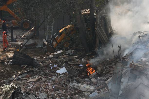
Mumbai is prone to 35 natural and manmade disasters, such as tsunamis, cyclones, flooding, landslides, bomb blasts, fires, oil spills, building collapses, tree collapses, road over and foot over bridges collapses, stampede, earthquake, power failures, nuclear and radiological disasters, and even sinking or collisions of ships, or war, according to a list of probable disasters prepared for the city by the Disaster Management Department of Brihanmumbai Municipal Corporation (BMC).
BMC will conduct seismic microzonation, hazard vulnerability risk assessment (HVRA) and develop a tsunami atlas to help administrative authorities, firefighters, and builders in decision making while developing infrastructure in the city.
The civic body said it would map areas that are prone to disasters and investigate their impact. Based on this information, BMC will come up with a standard operating procedure (SOP) for disaster response. The mapping will be linked to artificial intelligence (AI) for predictable analysis of probable disasters. This can be used for earlier warning and early evacuation.
A mini prototype of this plan is already active for disaster response during monsoon flooding for Mumbai. The system is used for evacuation in flood prone spots through predictions of waterlogging based on rain forecasts. It also has a disaster response and evacuation plan for residents living along the banks of the four rivers of the city—Mithi, Dahisar, Poisar and Oshiwara.
An SOP is automatically activated and also has evacuation details for these areas, with complete information on nearby civic shelters, transport services that can commute distressed residents and commuters caught up in flood to the shelters, food services in the area which have agreed to supply food to shelters, and nearby medical facilities. The second part of this prototype includes tying up with mobile service providers to send out area specific messages to residents living in the vicinity of the spot.
Make in Steel 2021
24 February
Click for event info
4th Indian Cement Review Conference 2021
17-18 March
Click for event info
As part of the HVRA, BMC will also study the short- and long-term impacts of disasters on livelihoods, as well as post-disaster rehabilitation. In cases where people's livelihoods are impacted, predictions will also include how long it will take for people to get back on their feet economically and what can be done to prevent loss of lives and livelihood in case a disaster strikes.
This data will be digitally available to the general public as well to determine the hazard to their plot or property and take decisions about construction designs of their properties. Once the entire exercise is complete, the BMC will conduct training sessions for elected representatives and locals to identify the possibility of manmade disasters and how to act fast in case of a natural disaster.
Through disaster response over the past decades, the BMC already knows the areas that are prone to disasters. For example, Malad is prone to landslides, the active faultline at Panvel will impact residents of Chembur, Govandi, and other areas in the east, tsunamis or cyclones will impact residents living along the coast of Mumbai the most, and south Mumbai has the most number of old buildings.
The list of 35 disasters prepared by BMC is further divided based on the magnitude of impact. For example, bomb blast as a disaster has been divided into blast in a train, blast in a hospital, blast at a public place, and blast in a vehicle. Tree collapse has been divided into signs that the tree or only a branch will collapse, versus a tree collapse and a branch collapse. Building collapse has been divided into partial collapse and building collapse, along with signs that a building will collapse or partially collapse and destruction of road traffic has been categorised as disruption due to strike, water logging, or mere traffic jams.
Image: Mumbai is prone to 35 kinds of disasters, according to the Disaster Management Division.
Also read: BMC to buy 37 machines to clean sewers