Outcome/FactsMumbai embarked on a $1.8 billion highway project to ease traffic congestion and curb the amount of toxic air pollutants admitted into the atmosphere.The eight-lane, 29.2 km highway will accommodate 130,000 vehicles a day and reduce travel time between South Mumbai and the western suburbs from two hours to 40 minutes.OpenRoads Designer enabled SYSTRA to identify interferences between the seawall and the structures saving 20 per cent in resource hours.The 3D models helped communicate the design to all stakeholders, showing the impact of design choices to both technical and nontechnical stakeholders early in the design process.
New coastal road will reduce traffic congestion and pollutants
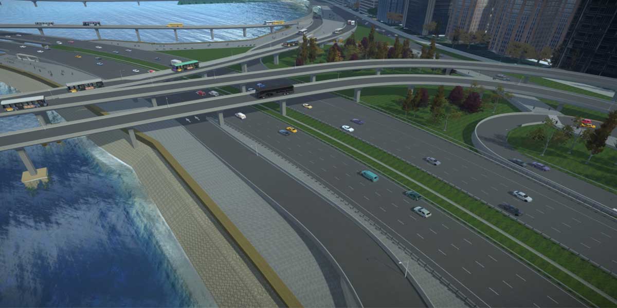
An increase in congestion on Mumbai’s roads has put a strain on the city’s infrastructure. The result has been long commute times with idling cars contributing to an alarming rise in poor air quality, inconveniencing the residents. To improve traffic flow, the Municipal Corporation of Greater Mumbai carried out comprehensive studies for the island city and its suburbs to identify how to ease the congestion, lower emissions and improve living conditions. The study found that a new coastal road was needed along Mumbai’s west side. Currently under construction, the eight-lane, 29.2 km highway will accommodate 130,000 vehicles a day and reduce travel time between South Mumbai and the western suburbs from two hours to 40 minutes. SAI-SYSTRA Group was hired as design consultant for Package II or the south end of the project. They are responsible for a 2.7 km, $306 million section of the $1.8 billion project, which consists of undersea tunnels, grade roads and bridges and an interchange that connects the road to the Bandra-Worli Sea Link. The project’s goal was to reduce traffic volume, improve air quality, and create green spaces and waterfronts for recreational activities. However, because of the limited space, SYSTRA had to reclaim 110 hectares, while the interaction of many of the components had to be visualized to detect and resolve clashes.
3D modeling software to identify clashes and save time
To overcome the mentioned challenges, SYSTRA needed to implement a 3D road design solution to model the highway, promenade, sea retaining walls, junction and interchange. They planned to use the software in the initial stage to design the horizontal and vertical alignment of the coastal road and the arm at the intersection near the sea, while they would use BIM methodology for the latter stage. SYSTRA searched for a software that would help them identify clashes with the sea wall and the structure to determine if alignments needed to be adjusted. Additionally, they wanted some technology that would allow them to model the corridor, which would be critical in helping them facilitate the design process. With the coastal road constructed on reclaimed land, they knew that it would be arduous and time consuming to calculate the necessary reclamation quantities using traditional methods. With innovative road design software, they knew that they could easily calculate the quantities in a fraction of the time of traditional methods.
Interoperable software to coordinate design across project team
Using 3D drive-throughs in OpenRoads Designer enabled the identification of interferences between the seawall and the structures saving 20 per cent in resource hours. Additionally, the dynamic nature of the 3D model enabled them to effortlessly define and modify the plan, saving them 50 per cent in design time. Furthermore, the software’s interoperability enabled them to coordinate the design across the entire project team, and LumenRT helped them to visualize the complex project and simplify the design effort to quickly gain stakeholder approval. Moreover, OpenRoads Designer’s ability to quickly resolve clashes optimised the design while improving output quality, which helped reduce construction costs. Bentley applications helped the team resolve issues at one location where the retaining wall obstructed the sea view from the promenade. Using the software’s 3D drive-through along the retaining wall edge helped SYSTRA understand the scenario and provided them with a clearer view of the problem to reach a solution.
“A project of this complexity required out-of-the-box thinking,” elaborates Amit Aggarwal, Team Lead, Highways, SAI-SYSTRA Group. “For that, our team decided to use Bentley solutions. The 3D modelling allowed our project team to coordinate its work internally and externally with the client. Given SYSTRA’s experiences using Bentley products in engineering solutions, especially in highways, our team was able to provide the solution our client was looking for.”
Corridor modeling feature facilitated design
In the project’s initial stage, SYSTRA used OpenRoads Designer’s robust features to design the horizontal and vertical alignment of the coastal road and the arms at the intersection near the sea before adopting a BIM methodology in the later stages of the project. They estimated that they saved 90 per cent in drafting effort compared to using conventional methods. The corridor modeling feature in OpenRoads Designer was a key factor in facilitating the design in addition to the help in identifying clashes and interferences. SYSTRA exported the 3D model into LumenRT to produce life-like animation, high-quality graphics and high-impact visuals for stakeholders. The precise visualisation allows stakeholders with non-engineering backgrounds and the public to understand the scope and impact of the project.
Softwares deployed
LumenRT, MicroStation, OpenBridge Designer, OpenRoads Designer