+
BIM helps create a digital twin in historic city
SMART CITIES

BIM helps create a digital twin in historic city

POWERCHINA Huadong Engineering Corporation (HDEC) is using BIM to provide the foundation of a co-called Digital Twin that the company says will transform the ancient Chinese city of Shaoxing.

The company is responsible for the digital engineering of Shaoxing’s new Urban Rail Transit Line 1. Construction of the 34.1 km line in the eastern coastal Zhejiang province is planned to finish in June 2021, with railway operations scheduled to commence in 2022. Digital workflows will increase productivity, improve quality, mitigate risk, and lay the foundations of a digital twin of the railway for use in operations and maintenance. The construction of the line commenced in 2017.

The city of Shaoxing carries a history of more than 2,500 years. With the title of Oriental Venice, the 21 sq km city is rich in lakes, rivers, and rainfall. With the new Urban Rail Transit Line 1, the city will be linked with the cities of Hangzhou and it’s Metro Line 5 via the Hangzhou-Shaoxing Intercity Railway. The 34.1 km line is expected to be constructed by June 2021.

HDEC is employing real-time analysis and data from various sources that are processed in a connected data environment to enhance the accuracy and impact of the decisions for the project. Furthermore, the digital approach will directly improve the project's efficiency, quality, and productivity while reducing the risk.

The construction of the Urban Rail Transit Line 1 is the largest infrastructure project in the city. It is mostly underground with 24 stations, 25 sections, one depot, a parking lot, two main substations, and a control center.

HDEC required complex software to meet the requirements and provide a solution to all the problems that can occur during the construction. The issues include limited space, hydrogeological conditions, the safety of the foundation pits due to the thickness of the soft soil, water leakage during construction, and other technical interfaces.

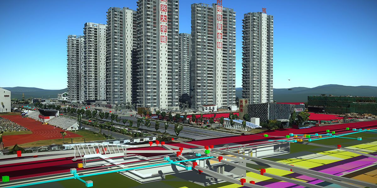
To address the issue of having a limited workspace and testing environmental conditions, HDEC has developed a 3D geology software, GeoStation, based on Bentley’s iTwin technology. The technology is used to create a 3D reality mesh using aerial photographs of the city. The unique approach enabled HDEC to save more than 800 hours of field data collection time while reducing the project's cost by CNY 3 million. With BIM technology and an automated monitoring system, the real-time data of the surroundings can be analysed to tackle any abnormalities.

POWERCHINA Huadong Engineering Corporation (HDEC) is using BIM to provide the foundation of a co-called Digital Twin that the company says will transform the ancient Chinese city of Shaoxing. The company is responsible for the digital engineering of Shaoxing’s new Urban Rail Transit Line 1. Construction of the 34.1 km line in the eastern coastal Zhejiang province is planned to finish in June 2021, with railway operations scheduled to commence in 2022. Digital workflows will increase productivity, improve quality, mitigate risk, and lay the foundations of a digital twin of the railway for use in operations and maintenance. The construction of the line commenced in 2017. The city of Shaoxing carries a history of more than 2,500 years. With the title of Oriental Venice, the 21 sq km city is rich in lakes, rivers, and rainfall. With the new Urban Rail Transit Line 1, the city will be linked with the cities of Hangzhou and it’s Metro Line 5 via the Hangzhou-Shaoxing Intercity Railway. The 34.1 km line is expected to be constructed by June 2021. HDEC is employing real-time analysis and data from various sources that are processed in a connected data environment to enhance the accuracy and impact of the decisions for the project. Furthermore, the digital approach will directly improve the project's efficiency, quality, and productivity while reducing the risk. The construction of the Urban Rail Transit Line 1 is the largest infrastructure project in the city. It is mostly underground with 24 stations, 25 sections, one depot, a parking lot, two main substations, and a control center. HDEC required complex software to meet the requirements and provide a solution to all the problems that can occur during the construction. The issues include limited space, hydrogeological conditions, the safety of the foundation pits due to the thickness of the soft soil, water leakage during construction, and other technical interfaces. To address the issue of having a limited workspace and testing environmental conditions, HDEC has developed a 3D geology software, GeoStation, based on Bentley’s iTwin technology. The technology is used to create a 3D reality mesh using aerial photographs of the city. The unique approach enabled HDEC to save more than 800 hours of field data collection time while reducing the project's cost by CNY 3 million. With BIM technology and an automated monitoring system, the real-time data of the surroundings can be analysed to tackle any abnormalities.

Next Story
Infrastructure Urban

APCRDA Approves Rs 9.04 Bn to Upgrade Infrastructure in 29 Amaravati Villages

The Andhra Pradesh Capital Region Development Authority (APCRDA), chaired by Chief Minister N Chandrababu Naidu, has approved Rs 9.04 billion for addressing key infrastructure gaps in 29 villages within Amaravati’s greenfield capital area, announced Municipal Administration Minister P. Narayana at the 51st CRDA meeting.The funds will be used to upgrade critical facilities including roads, drains, drinking water supply, sewerage systems, and street lighting. A detailed assessment revealed a 30 per cent shortfall in water supply, a total absence of sewerage infrastructure, a 40 per cent defici..

Next Story
Infrastructure Transport

Cabinet Approves Phase-1B of Lucknow Metro Rail Project Worth Rs 58.01 Bn

The Union Cabinet, led by Prime Minister Narendra Modi, has approved Phase-1B of the Lucknow Metro Rail Project in Uttar Pradesh. This phase covers an 11.165 km corridor with 12 stations—7 underground and 5 elevated—extending the city’s metro network to 34 km upon completion.Phase-1B targets the dense, historic parts of Lucknow, enhancing connectivity across key commercial, healthcare, tourist, and culinary hubs. Important areas served include Aminabad, Yahiyaganj, Pandeyganj, Chowk, King George’s Medical University, and landmarks like Bara Imambara and Rumi Darwaza.This expansion prom..

Next Story
Infrastructure Transport

Major Upgrades Planned for Tamil Nadu’s National Waterways

Tamil Nadu is poised for significant infrastructure upgrades across its National Waterways (NWs), with a focus on developing jetties, cargo hubs, and cruise tourism circuits, according to the Ministry of Ports, Shipping and Waterways. These projects aim to promote sustainable inland water transport and boost regional economic activity.Key projects include the development of Buckingham Canal (part of NW-4), with jetties planned at the following locations:Mahabalipuram to Ediyur BridgeCooum River near Marina BeachPulicat LakeEnnore Port to ETPS, specifically for cargo operationsOther National Wa..

Advertisement

Subscribe to Our Newsletter

Get daily newsletters around different themes from Construction world.

STAY CONNECTED

Advertisement

Advertisement

Advertisement

Talk to us?