+
LiDAR survey for second bullet train project begins
RAILWAYS & METRO RAIL

LiDAR survey for second bullet train project begins

The Light Detection and Ranging (LiDAR) survey for preparing the detailed project report (DPR) for the proposed Mumbai-Nagpur High Speed Rail (HSR) corridor started last week.

The proposed 736 km bullet train project is likely to link Nashik, Mehkar, Shahapur, Igatpuri, Malegaon, Wardha, Khapri, and Pulgaon, the National High Speed Rail Corporation Ltd (NHSRCL) told the media.

NHSRCL has proposals to conduct these surveys and prepare the DPR for seven High Speed Rail Corridors in India. Apart from the Mumbai-Nagpur corridor, other proposed bullet train projects include—459 km Delhi-Amritsar corridor, Varanasi-Howrah corridor, 865 km Delhi-Varanasi corridor, Delhi-Ahmedabad corridor, 711 km Mumbai-Hyderabad corridor and 435 km Chennai-Mysore corridor. Last year, the Indian Railways said that these seven new Bullet train projects will be completed using the public-private partnership (PPP) model.


4th Indian Cement Review Conference 2021

17-18 March 

Click for event info


India’s first Ahmedabad-Mumbai Bullet Train corridor will be 508 km long and is based on Japan’s E5 Shinkansen technology. The railway project will run bullet trains with speeds of over 300 km per hour.

As we have reported earlier, the aerial LiDAR survey technique is expected to save time exponentially. The first instance of the aerial technique for a railway project in India was adopted for the Mumbai- Ahmedabad High Speed Rail Corridor, chosen primarily because of its high accuracy. The ground survey using aerial LiDAR for MAHSR alignment was done only in 12 weeks against the 10-12 months if had been done through traditional survey methods.

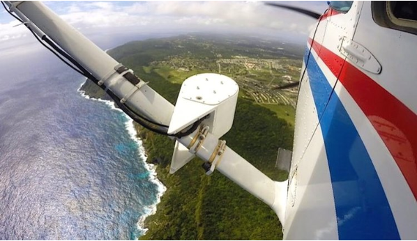
LiDAR surveys are conducted using a technology in which aerial LiDAR and imagery sensors are fitted over an aeroplane, and the airborne devices capture data related to the ground survey. High-power 100-megapixel cameras are used in the LiDAR technology to get clear pictures of the surrounding structures, trees and other minute ground details and topography.

Image Source


Also read: Bullet train project’s LiDAR-based survey underway

Also read: Laser-enabled aerial LiDAR for Delhi-Varanasi hi-speed corridor

Also read: Centre to invest in 7 new bullet train corridors

The Light Detection and Ranging (LiDAR) survey for preparing the detailed project report (DPR) for the proposed Mumbai-Nagpur High Speed Rail (HSR) corridor started last week. The proposed 736 km bullet train project is likely to link Nashik, Mehkar, Shahapur, Igatpuri, Malegaon, Wardha, Khapri, and Pulgaon, the National High Speed Rail Corporation Ltd (NHSRCL) told the media. NHSRCL has proposals to conduct these surveys and prepare the DPR for seven High Speed Rail Corridors in India. Apart from the Mumbai-Nagpur corridor, other proposed bullet train projects include—459 km Delhi-Amritsar corridor, Varanasi-Howrah corridor, 865 km Delhi-Varanasi corridor, Delhi-Ahmedabad corridor, 711 km Mumbai-Hyderabad corridor and 435 km Chennai-Mysore corridor. Last year, the Indian Railways said that these seven new Bullet train projects will be completed using the public-private partnership (PPP) model.4th Indian Cement Review Conference 202117-18 March Click for event info India’s first Ahmedabad-Mumbai Bullet Train corridor will be 508 km long and is based on Japan’s E5 Shinkansen technology. The railway project will run bullet trains with speeds of over 300 km per hour. As we have reported earlier, the aerial LiDAR survey technique is expected to save time exponentially. The first instance of the aerial technique for a railway project in India was adopted for the Mumbai- Ahmedabad High Speed Rail Corridor, chosen primarily because of its high accuracy. The ground survey using aerial LiDAR for MAHSR alignment was done only in 12 weeks against the 10-12 months if had been done through traditional survey methods. LiDAR surveys are conducted using a technology in which aerial LiDAR and imagery sensors are fitted over an aeroplane, and the airborne devices capture data related to the ground survey. High-power 100-megapixel cameras are used in the LiDAR technology to get clear pictures of the surrounding structures, trees and other minute ground details and topography. Image Source Also read: Bullet train project’s LiDAR-based survey underway Also read: Laser-enabled aerial LiDAR for Delhi-Varanasi hi-speed corridor Also read: Centre to invest in 7 new bullet train corridors

Next Story
Infrastructure Urban

India to Invest Rs 600 Billion to Upgrade 1,000 ITIs

As part of its drive to modernise vocational training, the Ministry of Skill Development and Entrepreneurship (MSDE), in collaboration with Gujarat’s Labour and Employment Department, held a State-Level Workshop at the NAMTECH Campus within IIT-Gandhinagar to discuss the National Scheme for ITI Upgradation.The consultation brought together key stakeholders from industry and the training ecosystem to align expectations and support implementation of the scheme, which aims to transform 1,000 Industrial Training Institutes (ITIs) across India using a hub-and-spoke model. The total outlay stands ..

Next Story
Infrastructure Urban

India Unveils Rs 600 Billion Maritime Finance Push

The Ministry of Ports, Shipping & Waterways (MoPSW) hosted the Maritime Financing Summit 2025 in New Delhi, bringing together over 250 stakeholders including policymakers, industry leaders, global investors, and financial institutions. The summit, held under the ambit of Maritime Amrit Kaal Vision (MAKV) 2047, focused on transforming India into a leading maritime power with strengthened financial, infrastructural, and technological capabilities.Union Minister Sarbananda Sonowal emphasised India's strategic progress, noting that average port turnaround times have dropped from four days to u..

Next Story
Infrastructure Urban

Govt Allocates Rs 500 Million To Boost Community Radio

The Central Government, through its ‘Supporting Community Radio Movement in India’ scheme, has allocated Rs 500 million to strengthen the community radio ecosystem across the country. The initiative aims to assist both newly established and long-operational Community Radio Stations (CRSs), ensuring their relevance to local educational, social, cultural, and developmental needs.According to the policy published by the Ministry of Information and Broadcasting, CRSs may be set up by not-for-profit organisations with at least three years of demonstrated community service. These stations are ex..

Advertisement

Subscribe to Our Newsletter

Get daily newsletters around different themes from Construction world.

STAY CONNECTED

Advertisement

Advertisement

Advertisement

Talk to us?