Bentley Taps Google AI, Street View for Roadway Asset Analytics
Technology

Bentley Taps Google AI, Street View for Roadway Asset Analytics
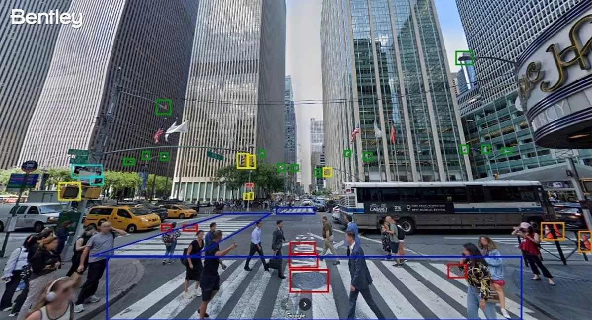
Bentley Systems has announced new asset analytics features powered by Google Maps Platform’s Imagery Insights, enhancing its Blyncsy product for faster, AI-driven roadway inspections. Unveiled at Google Cloud Next 2025, the solution leverages Google’s Street View, Vertex AI, and crowd-sourced imagery to automate road asset detection and condition monitoring.
The collaboration will help transportation agencies and consultants identify infrastructure concerns early and monitor changes over time, improving maintenance and speeding up post-disaster assessments. Street View’s 360-degree imagery offers detailed visual analysis, while Vertex AI helps develop models that predict infrastructure issues before they escalate.
“We have a history of leadership in applying repurposed imagery for roadway maintenance, and the addition of Google's 360-degree imagery and AI will further enhance the value Bentley provides,” said Mark Pittman, Director, Transportation AI at Bentley.
Yael Maguire, Vice President at Google Maps Platform & Earth, added, “Bentley combines infrastructure software with our leading AI and mapping tools to deliver powerful insights for mobility planning and maintenance.”
Google’s Imagery Insights will be generally available in Blyncsy later in 2025.

Photo: Bentley Systems
                                                                                  

Bentley Systems has announced new asset analytics features powered by Google Maps Platform’s Imagery Insights, enhancing its Blyncsy product for faster, AI-driven roadway inspections. Unveiled at Google Cloud Next 2025, the solution leverages Google’s Street View, Vertex AI, and crowd-sourced imagery to automate road asset detection and condition monitoring.The collaboration will help transportation agencies and consultants identify infrastructure concerns early and monitor changes over time, improving maintenance and speeding up post-disaster assessments. Street View’s 360-degree imagery offers detailed visual analysis, while Vertex AI helps develop models that predict infrastructure issues before they escalate.“We have a history of leadership in applying repurposed imagery for roadway maintenance, and the addition of Google's 360-degree imagery and AI will further enhance the value Bentley provides,” said Mark Pittman, Director, Transportation AI at Bentley.Yael Maguire, Vice President at Google Maps Platform & Earth, added, “Bentley combines infrastructure software with our leading AI and mapping tools to deliver powerful insights for mobility planning and maintenance.”Google’s Imagery Insights will be generally available in Blyncsy later in 2025.Photo: Bentley Systems                                                                                  

Next Story
Infrastructure Transport

JNPA Becomes First Indian Port to Cross 10 Million TEU Capacity

The Jawaharlal Nehru Port Authority (JNPA), located at Uran in Navi Mumbai, has become the first port in India to achieve over 10 million TEUs (twenty-foot equivalent units) in container handling capacity.With the recent expansion, the port now operates five container terminals with a combined capacity of 10.4 million TEUs, alongside two liquid and two general cargo terminals.Handling more than half of India’s container traffic, JNPA processed 7.05 million TEUs in 2024 and has moved 15.39 million tonnes of containers and 16.64 million tonnes of total cargo in the first two months of FY 2025..

Next Story
Infrastructure Transport

Nod for Rs. 36.26 billion Expansion of Pune Metro Line 2

The Union Cabinet has approved the Rs.36.26 billion expansion of Pune Metro Line 2, adding 12.75 km of track and 13 new stations to improve east–west connectivity across the city.The project aims to link Pune’s urban core with rapidly growing suburbs, supporting the city’s rising demand for efficient and sustainable transport solutions. This expansion is part of Corridor 2 of the Pune Metro and includes two key routes: Vanaz to Chandani Chowk (Corridor 2A) and Ramwadi to Wagholi/Vitthalwadi (Corridor 2B).It will connect residential, IT, and educational hubs in areas such as Bavdhan, Koth..

Next Story
Infrastructure Transport

Assembly begins for ‘Nayak’ TBM on Thane– Borivali Twin Tunnel Project

The assembly of ‘Nayak’, the first of four Tunnel Boring Machines (TBMs) for the Thane–Borivali Twin Tube Tunnel Project, has commenced at the Thane site. Built by German firm Herrenknecht AG and deployed by Megha Engineering & Infrastructure (MEIL), the TBM marks a key milestone in Mumbai’s ambitious 11.8-km underground road corridor beneath Sanjay Gandhi National Park.The twin tunnels will reduce the Thane–Borivali travel distance by 12 km and decongest Thane Ghodbunder Road. ‘Nayak’, with a 13.2-metre diameter, is designed to bore through challenging geological conditions ..

Advertisement

Advertisement

Subscribe to Our Newsletter

Get daily newsletters around different themes from Construction world.

STAY CONNECTED

Advertisement

Advertisement

Advertisement

Advertisement

Talk to us?